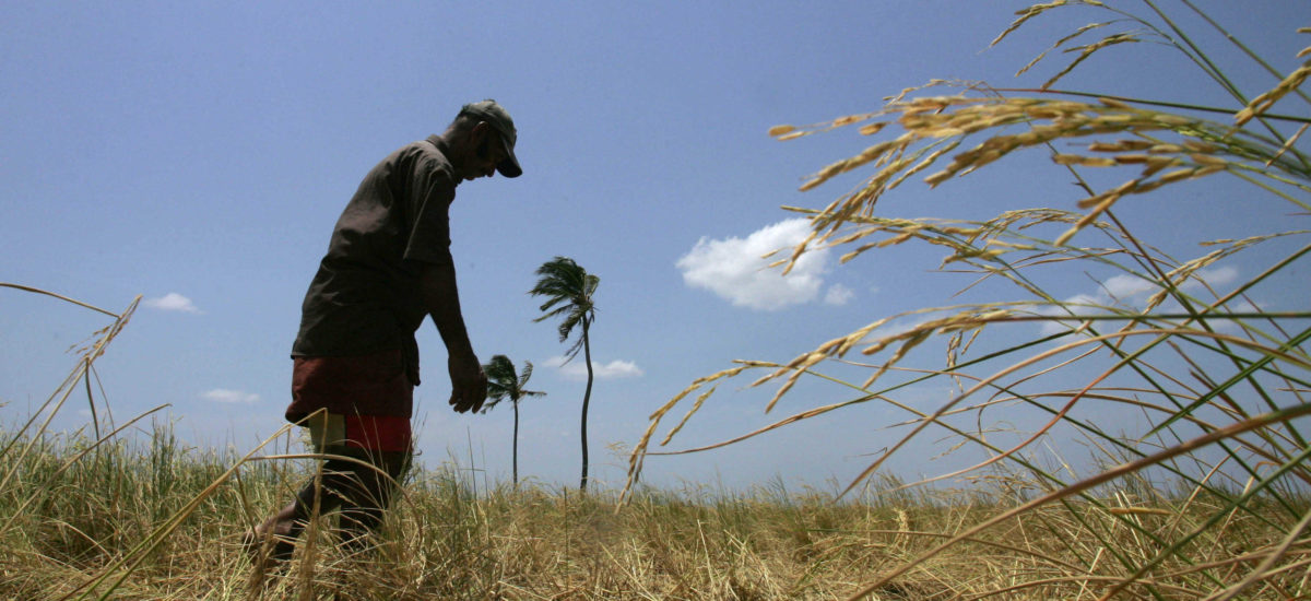

Photo courtesy Voice of America
When talking about conflicts around land in eastern Sri Lanka, explanations based on ethnic identity spring to mind. Sri Lanka’s ethnic majority, for example, is seen as having the right to cultivate their ancient lands in Gal Oya, or they are seen as occupying the traditional homelands of Tamil-speaking people. Such arguments are rooted in the notion that the powerful State has expanded its control over land through ethnicised colonisation. This notion, in turn, is embedded in a larger imagination of the rural areas as inhabited by a homogeneous peasantry (though divided along ‘the ethnic’) that follows what the powerful State prescribes, as this state provides them (though preferentially) with essential services including land.
However, are these explanations sufficient to understand the reality of land conflicts faced by people who depend on the land for their livelihood? To learn more about this problem, Shahul H. Hasbullah, who unfortunately left us all too early, and myself selected the larger Akkaraipattu and Gal Oya Right Bank region in the Ampara district to analyse a series of land conflicts that people had mentioned to us.1
Our insights challenged the simplified explanations based merely on the ‘ethnic’ aspect. We found that such a gaze overlooks the importance of crucial political-economic factors at play across ethnic lines. Conflicts around land can emerge when people use land for different purposes; when the many branches of the local state bureaucracy handle land issues in an un-coordinated way; and when locals with competing interests organise and struggle with the state bureaucracy.
To substantiate our argument, we embark on a brief journey starting in the Akkaraipattu area along the east coast, moving inland to reach Senanayake Samudra.
Urban land-use along the east coast
Traveling along the east coast, the density of population and the importance of land for settlements become apparent. As is the case almost everywhere in Sri Lanka, the population has increased in the recent past, leading to a scarcity of land to construct new houses for one’s descendants.
This intensification of land-use also entails a need for increased interactions with the local administration. Until 1972, the entire stretch of land from the mouth of the Gal Oya river down to Thirukkovil was part of the same Akkaraipattu Assistant Government Agent’s Division. Muslims, Tamils, and the few Sinhalese that lived here went to the same officers for land administration matters and other public services. Today, however, this area is split into five Divisions (now called Divisional Secretariat Divisions, DSDs: Irakkamam, Addalachchenai, Akkaraipattu, Alayadivembu, and Thirukkovil). The main reasons for this fragmentation were that people of a certain place ‘desired a land of their own’, and that they preferred access to government offices staffed by ‘their people’. We learned that influential persons and local organisations (welfare associations, religious institutions, farmers organisations) lobbied with the respective Members of Parliament (MPs), and pressured them to influence ‘Colombo’ to declare a separate Division distinct from ‘the others’.
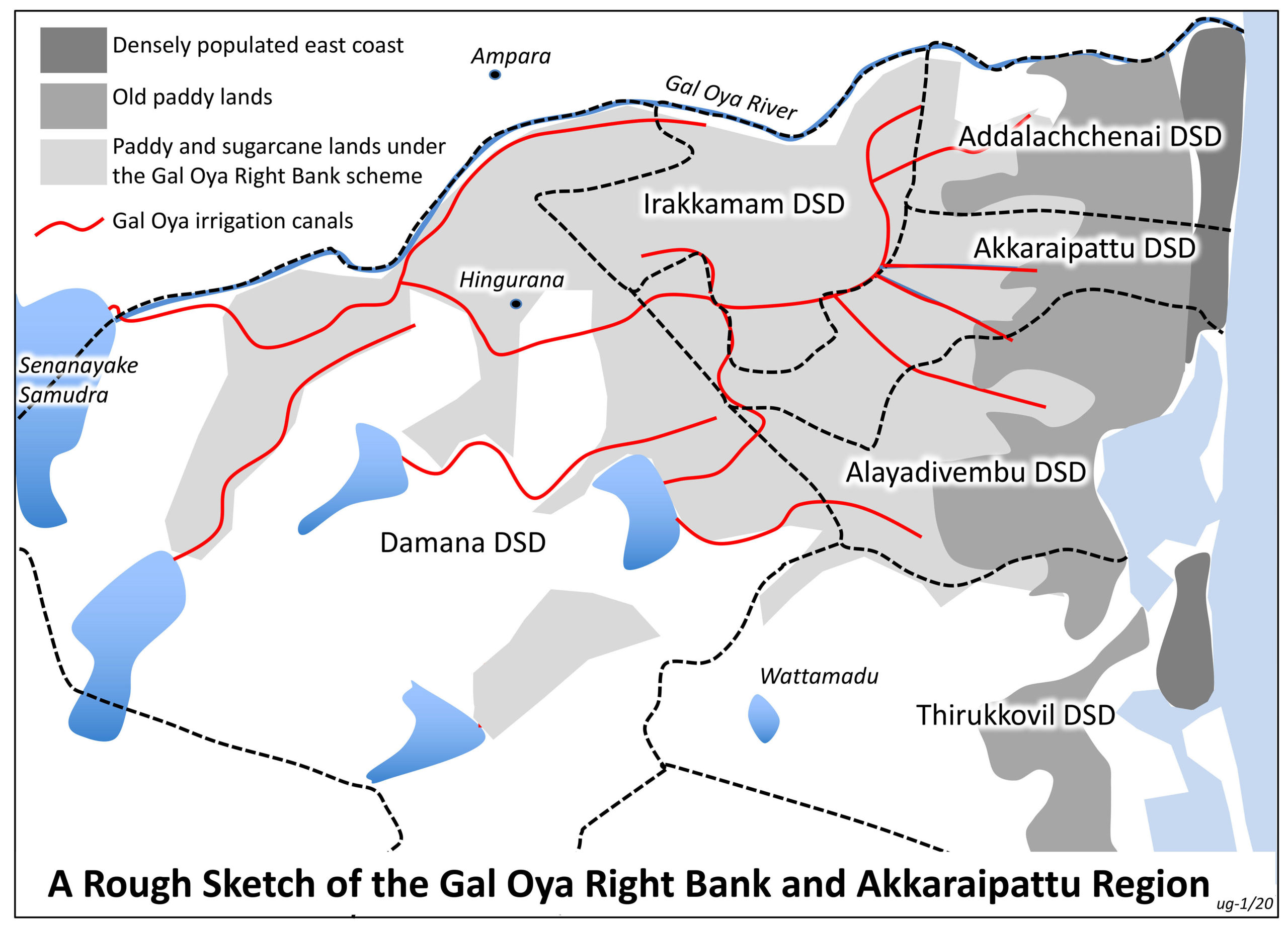
Each of these Divisions is now almost exclusively inhabited by one ethnic group. But three adjoining Divisions are home to Muslims (Irakkamam, Addalachchenai, Akkaraipattu), while the two others separate Tamils from Tamils (Alayadivembu, Thirukkovil). Thus, delimitations were not necessarily determined by the central state; ‘identity of place’, or something similar, has inspired local organisations to pressure their patrons. As a matter of fact, the adjoining Division to the west (Damana, almost exclusively inhabited by Sinhalese) remains as it was in the early 1950s.
While each of the five Divisions is ethnically homogeneous, economically, they are highly stratified. A large stratum (or class) of households in each of the Divisions struggles to make ends meet. They often depend on a small stratum of better-off households (deriving their status from trade, professional occupations, or global connections) to sell their labour in agriculture or construction work.
The old paddy lands
A little inland from the densely populated coastal area, we find a huge stretch of low-lying paddy land. This is the original agricultural zone used by Muslims and Tamils, and almost all land is privately owned. During the Grow-More-Food campaign in the early 1940s, this zone was enlarged with the support of the then Assistant Government Agent of Kalmunai by making additional State land available for paddy cultivation. Another state intervention, though, created problems. Many of the irrigation and drainage canals of the Gal Oya Right Bank scheme ended along this land. They brought water that went beyond the scheme’s perimeter, and started to flood parts of it along the settlements. The Gal Oya authorities installed some water pumps, but this did not solve the problem, and affected people had to agitate on their own for further action. Farmers’ organisations, mosque federations, and welfare organisations continuously pressured local leaders to address the issue. Some of the resulting measures helped to reclaim some land, but many of the affected lost their land for good.
Land under the Senanayake Samudra
Proceeding further inland, we reach the vast paddy and sugarcane lands of the Gal Oya scheme. Lands closer to the east coast are cultivated by Muslims and Tamils, living in the five Divisions above. As we cross the boundary of Damana, the land is cultivated by Sinhalese. All these lands were made cultivable through the Gal Oya project in the late 1950s, and were then lent to Sinhalese, Tamil, and Muslim settlers under Land Development Ordinance (LDO) permits.
The Gal Oya scheme plays a crucial role in the ethnicised nationalist ideologies. Indeed, MPs representing Sinhalese interests pushed the allocation of the land to ‘their people’. Similarly, though, Muslim MPs supported their people in accessing the land kachcheries in charge of land allocation. Tamil people, on the other hand, had great problems in accessing these kachcheries, and thus land, as their leaders generally opposed the scheme outright – and thus refused to provide support.
But having privileged access to land due to belonging to a ‘ privileged’ ethnic group has not necessarily translated into better livelihoods. Paddy and sugarcane farmers from all ethnic groups are confronted with similar political-economic challenges: accessing essentials like seed, credit and water; finding land and off-farm employment for the younger generation; finding pastures for their cattle; and dealing with an array of local government officials.
Consider the water case, for instance. Studies in the 1980s revealed that the state administration did not ensure proper water distribution. Therefore, many farmers – whether Muslim, Sinhalese or Tamil – were forced to ‘illegally’ tap canals, or to mobilise their political leaders to pressure the irrigation staff. One study even noted that “Gal Oya was considered to be one of the least popular [government] field postings in the country”. Later, farmers’ organisations were introduced to improve the situation, but access to water continues to be a challenge for many families from all ethnic groups.
Sugarcane farmers face additional challenges. A large part of the land under the Right Bank canal was parceled out to smallholders under LDO permits, with the obligation to grow sugarcane for the Hingurana factory. However, mismanagement paralysed the factory’s operations, and the smallholders were often unable to sell their cane. The factory then fully closed in 1997. With this move, the farmers – whether they were Sinhalese, Tamils, or Muslims – were again left ‘high-and-dry’. Fed-up with this vulnerability, they switched to paddy cultivation. It was only in 2009 that the sugarcane factory re-opened. All the smallholders whose LDO permits were bonded with the condition to grow cane were now asked to switch back from paddy to sugarcane. Based on their troubled experience with this crop, many hesitated to do so, and many continue to fear an uncertain future.
Contested pasture lands
Finally, we move southwards, leaving behind the Gal Oya scheme and entering State land covered by jungle and grasslands. We visit Wattamadu, a piece of land that was sparsely used until the early 1970s. This changed when people arrived in search of new pastures. We need to recall that pasture lands used by east coast farmers were lost because they were converted to paddy land under the Gal Oya scheme. Therefore, some Tamils and Muslims went south and came to Wattamadu where they found an ancient irrigation tank and good pastures. However, people in search of paddy land came here as well, partly due to the increase in population, partly because the LDO permits allow only one of the descendants to inherit the land, and partly because they lost their land through the waterlogging mentioned above. In Wattamadu, they found the same ancient irrigation tank and good soil.
Soon, the cattle owners organised as a Cattle Owners Association, and they approached the Government Agent of Ampara district, who gave them a permit to use 4,000 acres of State land as pastureland. This gave a boost to cattle breeding, and paddy farmers started to feel its repercussions when cattle trespassing increased. Thus, they organised themselves as a separate Farmers’ Organisation, which was registered with another State agency, the Department of Agrarian Services. This gave them access to the irrigation tank and the right to cultivate paddy. By the early 1980s, we thus find two ethnically mixed professional groups, both in possession of State documents (though issued by different branches of that State) providing them the right to use the same piece of land.
Both groups, though, suffered from the civil war. Depending on the encounters, either the Muslims or the Tamils suffered more, which gradually affected the professional groups’ ethnic composition. The Paddy Farmers’ Organisation became dominated by Muslims (though still having Tamil members), while the membership of the Cattle Owners’ Association was more Tamil (though not exclusively). This segregation has been further exacerbated because Wattamadu is now located (as a consequence of the delimitation processes) within the Tamil-dominated Thirukkovil Division. People claim that the staff at the Divisional Secretariat tend to give preferential treatment to Tamil land-users.
To complicate things further, in 2010 the central government declared Wattamadu as a part of a new Forest Reserve to now be managed by foresters. This came as a complete surprise to all people earning their living in Wattamadu, be they paddy farmers or cattle herders, Tamils or Muslims. The declaration, in principle, denies them the use of this land, despite the fact that they all have legal permits to do so. Both professional groups are now trying to challenge this verdict at different courts.
The urgency of going beyond the ‘ethnic’
This brief journey through a part of eastern Sri Lanka highlights just a few of the challenges that people have to face, independent of their ethnic belonging. We see at least five issues that underlie these challenges:
(1) Land means different things to different people: a space for settlements and to build a house, a territory of one’s own group (however defined), a place to cultivate paddy, or sugarcane, to graze livestock, a forest reserve, and so on.
(2) Different people have different claims on land: While sugarcane farmers (across ethnic lines) switched to paddy, they are now forced to return to cultivate sugarcane. While east coast farmers need land for paddy cultivation, the neglect of drainage canals on the part of irrigation planners flood the land. This diversity of interests also shows that the received notion of ‘the peasantry’ (in the singular) carries no analytical clout at all. Many households have diversified their income sources beyond agriculture, either because they had surplus to invest in other income opportunities, or because their land-based income was insufficient.
(3) The local State is highly divided: It is the role of the State to regulate the diverse claims to land, and to arbitrate in cases of conflict. However, people have to contact the Grama Niladari, the Land Officer, the Forester, the Irrigation Engineer, the Agricultural Instructor, or the staff at the Pradeshiya Sabha or the Divisional Secretariat. Although these are all officials linked to the same State, they represent different branches. Our study shows that these branches often operate in isolation.
(4) People often address land conflict collectively: We did not come across the ‘passive peasant’ who depends on State patronage. What we found is an array of local organisations, which are mobilised depending on the nature of the perceived grievances. We also found that these organisations are rather skilled in negotiating with the bureaucracy, be it to contact the local offices expected to favour one’s cause, or to pressure one’s patrons to engage with higher-level state officials.
(5) Occupational ‘identity’ is central: Land is contested because paddy farmers, cattle herders, foresters, sugarcane cultivators, or people in need of land for housing have very different interests. Of course, such occupational interests may intersect with other markers of identity. Living in one locality can make paddy farmers more familiar with each other than with those living in another place, or sharing the same religious beliefs can bond people together. But we found that concerns directly related to people’s material livelihood often take centre stage.
These social, political and economic complexities at the grassroots were simplified and narrowed down over the last decades to a single common-sense-understanding in which people quarrel over land simply because they belong to different ‘ethnic’ groups. Unfortunately, this common sense is rarely questioned. In fact, it is further nurtured by partisan political entrepreneurs, and land has become a central player in the nationalist-ideological blame-game.
This should not be. After all, Sri Lanka has a Land Commissioner’s General Department with the task to “promote a society with undisputed lands”. It also has a Land-Use Policy Planning Department “to introduce scientific land use planning procedures” (see the organisations’ homepages). All these institutions are equipped with staff from the head offices in Colombo down to the provinces, districts and the Divisional Secretariats. We strongly propose that these officials need full support – but that such support has to go beyond the ‘ethnic’, and has to be grounded in a critical discussion of the mundane political-economic realities that people at the grassroots have to confront.
1 Hasbullah S.H., Geiser U. (2019): Negotiating access to land in eastern Sri Lanka – social mobilisation of livelihood concerns and everyday encounters with an ambiguous state. International Centre for Ethnic Studies (ICES), Sri Lanka. ISBN: 978-955-580-233-8. https://ices.lk/publications/negotiating-access-to-land-in-easten-sri-lanka/