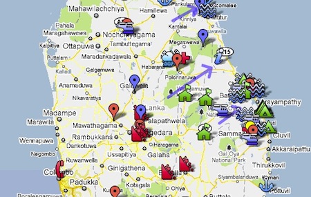
View Flood-affected areas in Sri Lanka – January 2011 in a larger map
The map above identifies the main flood-affected regions, sites where relief and rescue operations have been conducted, areas prone to landslides and specific locations that are at risk. Please click on the link below the map to view it on a larger screen. You may click on individual markers for detailed information and zoom in to view the location of specific shelter camps located in the east. Please note that this map is updated as soon as the Editors of Groundviews receive detailed information and reports from the ground.
After our last updated post on 12 January 2011, a Daily Mirror SMS update at 12:50PM reported that there were 21 deaths and over 1,000,000 people affected as a result of the floods and bad weather that continues to devastate these regions. The Eastern Province is the worst affected with over 860,000 flood victims according to the latest figures released by the Disaster Management Centre. There have been widespread reports that it has become increasingly difficult to access specific areas due to submerged or damaged roads and the prevailing weather conditions in the North Central Province and the Eastern Province. The Director General of Disaster Management Centre stated the following in a news report published by the Daily Mirror,
Batticaloa District is worst hit by the floods with 533,000 people belonging to 30,264 families have been displaced. He said eight deaths have been reported from the district and 225 displaced camps have been set up in the district.
He said the district is experiencing a rainfall of 113mm/day continuously (Emphasis ours.) Yesterday it had been 200mm. Major General Hettiarachchi said two air force helicopters had been deployed to distribute relief and to rescue the affected people but they could not be taken off the ground due to bad weather yesterday as well.
More than 200 tanks have been extensively damaged while nearly 20,000 acres of paddy land were also destroyed.
Overall 996,757 people have been affected by the floods with 1727 houses have been fully destroyed while 12,151 have been partly destroyed. Total numbers of deaths stood at 18 while 49 were injured as at yesterday afternoon. Some 52, 391 families who have been displaced have been housed in 502 camps.
The Daily Mirror notes that Health Minister Maithripala Sirisena has informed “officials about the necessity to repair the submerged roads as early as possible as it has hampered the relief supply to flooded areas in the country.”
We now face a real threat of severe food shortages due to the complete destruction of over 130,000 acres of paddy field. Agriculture Minister Lakshman Yapa Abeywardhana stated the following to the Daily Mirror,
“There is no doubt that we need an advanced strategy to face the food crisis that is inevitable. We can have a better picture only after the flood waters have fully receded. Therefore, we cannot say what kind of response we have to the crisis right now. What I can assure is that the government is going to face this with resolve and people must be prepared to it.”
Over a quarter of Sri Lanka is currently under water and 40 per cent of cultivated areas are submerged according to the Minister of Agriculture.
Update at 14:26PM: The death toll is now at 23.
Update on 15/01/11 at 4:13PM via JNW SMS update: “Total 1,053,718 persons affected by floods. 3744 houses fully damaged and 19,534 partially damaged. 37 deaths with 18 in Batticaloa – DMC – JNW.”
###
HOW TO HELP
The Editors of Groundviews appeal to all our readers to assist in any way possible and to spread the word. For more information on how to help the victims of flood-affected areas, please visit our previous post here.
